Post 158: 13 April 1998 Day 2 – Treen to St Just – 11½ miles
It was a beautiful sunny morning as I bade farewell to Rosemary and the tiny hamlet of Treen. Soon the sea came into view, glistening bright blue with white specks.

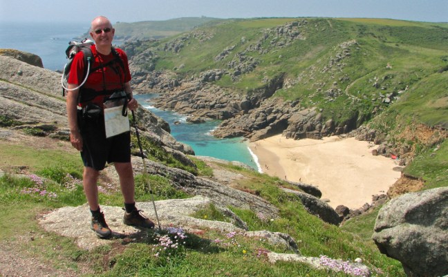
I dropped down to the sandy beach of Porthcurno, for once almost empty of tourists. My favourite beach.
It was still only 10.00am. and a group of overseas teenagers were the only other people on the beach; they kindly agreed to take my photo with a backdrop of golden sand, blue sea and a dramatic headland.

Had I not remembered that I had a full day’s walk ahead I could have stayed in this idyllic setting. But a day of great promise lay ahead, including Land’s End.
Just up from the beach beyond the car park was the Museum of Submarine Telegraphy – a unique centre for the study of early international communications. The museum is underground, in tunnels built into the granite cliffs during the Second World War, to protect the telegraph station. To my great surprise I discovered that this quiet secluded spot was the home of the world’s largest submarine telegraph station. This all began as far back as 1870 when Porthcurno became the landing site for an all-undersea telegraph cable link between England and Bombay, India. In 1872 the three companies that had each laid a portion of the Porthcurno to Bombay cable merged to form the Eastern Telegraph Company and the system itself had been extended to Australia. The Eastern Telegraph Company and associated companies went on to develop a worldwide submarine cable network. Porthcurno was the gateway to the network and in time became the world’s largest cable station with fourteen cables in operation.
In June 1900 Marconi installed an experimental wireless station on the Lizard and succeeded in communicating with another Marconi station on the Isle of Wight, proving beyond doubt and against the opinion of ‘experts’ that his newly developed ‘wireless’ waves could travel beyond the horizon. Marconi was soon to transmit across the Atlantic without having to lay expensive cable. The cable station at Porthcurno closed in 1970 by which time the Eastern Telegraph Company had become Cable and Wireless, and Porthcurno was also a telecommunications training college.
Leaving Porthcurno I re-joined the coastal path as it climbed steeply to another unique attraction, the auditorium of the Minack Theatre carved from the golden cliffs.

From 1931 until she died in 1983 the open air Minack Theatre was planned, built and financed by one remarkable women; Rowena Cade. An exhibition centre records her life and achievements through models, photographs and audio-visual display. Each summer from May to September, actors, singers, musicians, comedians and dancers perform at this magnificent location, which can seat an audience of 750. To attend a performance here is a unique and memorable occasion, but on a cool evening don’t forget the blanket and dram of whisky.
From the top of the next promontory there were fine views ahead and a fine descent to above the sandy beach of Porth Chapel.
 With care it is possible to descend to the beach; on a hot summers day it can get quite busy. Just beyond the beach there were the remains of a small two-roomed 8th-century chapel largely overgrown now with vegetation. One room was believed to provide accommodation and the other would have been the chapel.
Just a few steps up from the chapel, also to the right of the path, was the Porth Chapel Holy Well, a small roofless three-sided granite structure built on a large natural stone covering the spring. Where the path forks I turned right to follow a path for just under a ¼ mile to visit the lovely church of St Levan. I entered the churchyard by a well-preserved coffin stile with stone in the middle on which to rest a coffin and seats for bearers to rest. The present church dates from the 13th century with 15th century additions. There is a splendid Celtic cross within the churchyard.
Returning to the main coastal path I reached the tiny hamlet of Porthgwarra with a cave leading to a sandy beach with a few small boats.
The cave was blasted through by miners so that boats could be pulled to a higher level. Ascending to the next headland of Gwennap Head I could see large black and red landmarks (a bit like clowns’ hats), warning shipping away from the dangerous rocks in the area.
The coastal path became better defined but more exposed as I drew nearer to Land’s End. The scenery and walking was a delight as I marched enthusiastically through rocky outcrops, grass and heather towards my goal, the end of England. There was a pleasant descent to Millbay, also known as Nanjizel, where some twenty years earlier was a relatively accessible sandy beach where I frequently sunbathed. However, nature has demonstrated its power by throwing huge boulders onto the sand and making sunbathing difficult. However, as I crossed the footbridge over the small stream it was a pleasant place to stop, sheltered from the wind, which blows strongly across the headland.
Continuing along the headland the dramatic Armed Knight granite outcrop came into view; an opportune time to take out the camera.
 Dolphins and seals are frequently seen in this area but you need a good zoom to record them on film (this was pre-digital!). The power and grandeur of this southwest tip of England was evident as waves pushed on by running swells and tides crashed against the huge granite outcrops forming 200-foot cliffs and crags. Out to sea the Longships Lighthouse could be seen 1½ miles offshore and the Wolf Rock Lighthouse further out to sea. I was very fortunate to see the Scilly Isles as low humps on the horizon, some 28 miles south west in the Atlantic. The Scillies are Britain sunniest spot and some of it was shining on me.
After this wild beauty there was a shock as the white Land’s End theme park came into view. In the summer, when seen from a distance, visitors mill around like ants. They may have driven hundreds of miles or even journeyed from abroad to taste the Land’s End experience, but by walking there you truly experience the Land’s End peninsula. I had felt the hard granite and soft golden sands under my feet, tasted the salty sea air, felt the warmth of the sun, been dazzled by the bright sunlight reflecting off the sea, pushed by powerful winds, drenched from the driving rains and damp sea mist, seen the bright yellow of wild daffodils and gorse and purple haze of heather and felt the undulating contours of this remarkable landscape. Arriving in their cocooned cars they enter the cocooned buildings to the cocooned Land’s End experience. However, I didn’t deny myself all the ‘tourist honey-pot’ pleasures on offer and had a well-earned icecream and pint of beer. Tourists were queuing to have their photograph taken next to the Land’s End sign indicating how far they were away from home. On some summer evenings there are firework displays, which become very ‘surreal’ if the sea mist descends.
I descended to the ‘First and Last House’ near Dr Syntax Head, the mostly westerly point of the United Kingdom. I did not linger too long as there was the dramatic northern section of the Land’s End peninsula awaiting me.
Just off the coastal path, Maen Castle Fort was soon passed, a stone cliff castle dating back to 300BC.
There have been many shipwrecks in this area.


Then the former coast-guard look-out was reached giving wide ranging views towards Whitesand Bay and the golden sands of Sennen beach.
 The path dropped steeply down to Sennen Cove, a former fishing village but now a retirement and resort centre. I soon reached the round house, an old circular capstan house, which offered the opportunity to view paintings and drawings of the area. After passing the lifeboat station there are a number of cafés where icecreams, Cornish pasties, fish and chips and tea could be purchased. In summer the area gets very busy. Where the road bears steeply uphill a car park leads down to beach and on a sunny day it would be tempting to have an hour or two enjoying the golden sands. For those preferring a quieter beach it is best to continue round the next headland to Gwenver beach. Both beaches are popular with surfers although the latter beach is more popular with topless sunbathers. However, as it was early spring there were no such distractions and I scurried on with a few miles of energetic and dramatic coastal walking still to do.
At the headland of Nanven I descended to a path above the stream and followed it inland through bracken to the Lands End Youth Hostel (St Just).
This large white building stands prominently overlooking the secluded Cot Valley and in exceptionally strong winds in the late 1970’s nearly lost its roof. There can be a funnelling effect as the winds roar straight from the Atlantic up the valley. In the more sheltered spots surrounding the hostel lush plants and trees grow profusely, warmed by the air straight off the Gulf Stream. The Australian warden grows many of her own vegetables and fruits and uses the ingredients to make sumptuous ‘home produced’ meals. There were few guests at the hotel, three elderly ladies who were regular customers, a New Zealand lady called Gillian who was having six months off having left her job in a solicitors office and a couple of climbers from Leeds who didn’t seem very convincing as to why they were climbing.
In the evening I decided to visit some former neighbours when I had lived in St Just between 1975and 1979. This inevitably resulted in a visit to a number of the five St Just pubs and we threw the British Legion bar in for good measure – if you want to meet true St Just locals go to the British Legion. With a torch and unsure step I just about managed to find my way back along winding lanes to the hostel. I was relieved that I had a relatively easy days walking planned for the next day including a potter around England’s westernmost town, St Just.
