Post 99: 15 January 2017 1,000 Mile Walk Challenge
After a week away it was back to my ‘bread and butter’ walk through the village with one or two extras, including collecting The Sunday Times, which would take me a week to read! The Yorkshire Wolds could not be seen in the mist.

I soon discovered that the paths were covered in water from light rain, but underneath there was black ice. I had not put spikes on or taken my trekking pole. So the only solution was to walk like a Penguin. This advice I only heard recently, which shows that after 60 years of walking there are still new things you can learn. You basically take smaller steps and sort of waddle a little, keeping your arms fairly close to your side. It does actually work and reduce the risk of a fall. Penguins have evolved over millions of years and are experts on ice and thats how they get about. Occasionally they slide on their front, but I wouldn’t recommend that.

Another thing I learned is that if you stop and chat to people it increases the mileage measured by the app Mapmywalk. Presumably you don’t stand completely still and so it adds miles.
Miles Walked 4.02
Calories 457
8,200 Steps
Average Pace 18.37 Minutes Per Mile
Elevation Gain 51.5 feet
Minimum Elevation 36.4
Maximum Elevation 84.5
Now to go back to how I am getting on with walking the Cumberland Way in 1994. This was before mapmywalk apps were invented.
31 March 1994: The Cumberland Way, Day 5 – Dockray to Eamont Bridge – 16 miles
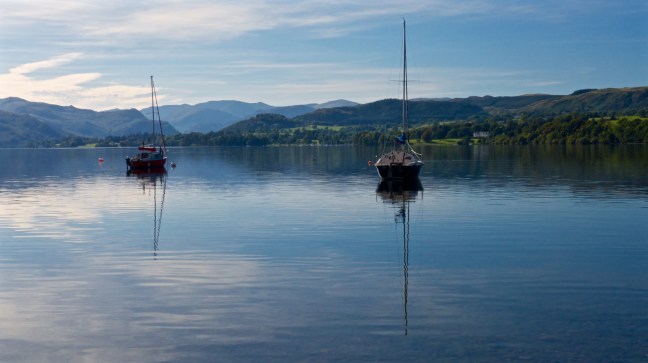
After a huge breakfast, we set off in drizzle to the impressive Aira Force, formed as a result of Aira Beck being confined to a narrow gorge. The path then skirted Gowbarrow Fell giving fine views of the head of Ullswater far below, with the Helvellyn range of mountains forming a backdrop. Here there are fine views of Ullswater.
However, you will have to make do with a photograph taken from a boat on Ullswater, which I took more recently.
and a slideshow:
The remainder of the day was spent in gentle descent, to eventually follow the River Eamont to the small village of Eamont Bridge. Here Alan left us, reputably to return to work, or was it just a coincidence we had now left the mountainous region?
Eamont Bridge has two prehistoric henge monuments, Arthur’s Round Table and the Mayburgh monument. The former was used for religious purposes and was probably of the early Bronze Age period, about 1800BC. The latter was of late Neolithic period, about 2000BC, again having religious origins.
Having walked 62 miles, unscathed, through some of England’s most mountainous area, Dan then proceeded to stub his toe on a step leading to his bedroom. I burst out laughing as he let out an almighty yelp and hopped around on one foot. It was not funny as he lost a toe nail and gangrene could have set in? Then of course leg amputation which would have spoilt the walk.
What was worse, there was some doubt that evening as to whether he could walk to the pub. Grimacing, he overcame the agony, hobbling to the village until we eventually found an inn with the following sign:
In this Hive we are all Alive
Good Liquor makes us Funny
If you be dry step in and try
The Virtue of our Honey
With such an invitation how could we resist?
