Post 35: 6 April 1991: Day 9 – Grinton Lodge Youth Hostel to Bolton-on-Swale – 18 miles
We left Grinton Lodge at 9.30am, in fine weather, taking a short cut to Merrick Priory by crossing a ford. The only problem was that, on arrival at the ford, it was found to be in flood. Never go for short cuts, they always involve more mileage.
As a result of my mistake we had to follow the B6270 to Marske; the only consolation was to see a lamb born by the roadside. At Marske we found a seat (real luxury) on which to have lunch, at which point a crowd of elderly coast to coasters came along with video cameras. They were doing the walk in separate day sections, looking more like Japanese tourists rather than serious walkers.
Good progress was made to Richmond where, on passing a pub, Clint popped his head out and dragged us inside.
‘It’s the Grand National today,’ he said. ‘What’ll you have to drink?’
‘Guinness please, I thought it was at three o’clock and it’s only two now,’ I replied.
‘That’s right, make yourself comfortable.’
Escape from the rain for the Grand National
Hearing the rain outside there seemed little choice, but I remembered we still had over seven miles to walk and excessive drinking and walking don’t mix. Events like the Grand National make you feel part of nation, but since Sky television came along these ‘national events’ on terrestrial TV have become fewer and fewer. For example, what Englishman wants to watch Russia play Italy at football when England are playing a pre-World Cup match? Unfortunately, unless you can afford Sky you have no choice. Similarly, what Englishman wants to watch Scotland and Australia play rugby when England are playing the All Blacks? My childhood days were spent waiting for football on Match of the Day or live Sunday afternoon football, now Sky has the big matches and little is left for the rest of us.
At about 4.15pm, we left the pub fully rested, but a little worse for drink. The rain still poured down but we didn’t care. We slithered along the mud alongside the River Swale until at 7.15pm we arrived at our pre-booked bed and breakfast.
‘Thought you were never coming,’ the farmer said.
‘Yes, we were a little delayed watching the Grand National.’
‘The wife will show you to the accommodation.’
Clint and Wendy were shown to their en-suite accommodation in the farmhouse, whereas Archie, Dave and myself were shown to the stables. Water for washing was provided by a bucket, there were unheated outside toilets, shower and washrooms. I had booked the accommodation! I decided to wait for the other four to have their baths inside the farmhouse, then, just as I was getting in the bath for a long-awaited soak, the fuses blew and I was in pitch darkness. To make matters worse there was no hot water. A low point of Coast to Coast.
Please note this will be the last post for 2-4 weeks as I will be on Grandparent duties during February. The diaries will resume towards the end of February/early March, after my second grandson is born.
5 April 1991: Day 8 – Keld Youth Hostel to Grinton Lodge Youth Hostel – 13 miles
Keld is at the crossroads of the Pennine Way and the Coast to Coast. After a muddy lane to a footbridge East Gill Force is reached. Swaledale and the waterfall are most dramatically viewed in the depths of Winter and therefore I have included in this section photographs taken at the beginning of December 2008.
East Gill Force
We left Keld Youth Hostel at 10.15am in light rain, somewhat late due the extensive foot repairs Archie had to do. He had about twenty blisters to attend to, as well as a swollen shin. The diagnosis was that his relatively new boots were to blame and it was hoped that by loosening them some of the problems would be rectified. It was either that or amputation and the latter seemed a bit extreme, especially as we had a relative short day. In order to try and ease Archie’s suffering, we decided to follow the low-level route along the River Swale. One of the characteristics of Archie was that he never complained about his aches and pains and, unless asked, wouldn’t reveal that he was in pain.
The delightful village of Muker was soon reached. The name is Norse in origin meaning ‘the narrow newly cultivated field’. In early June the hay meadows hereabouts are a delight.
Near Muker
Arriving at Gunnerside, we spotted a long line of rucksacks outside the pub and decided the Black Country Stompers must be inside. This assumption was correct and we joined them to find them again disputing which route they should have taken. The super-fit were wishing they had taken the high-level route, while the rest were content to keep to the low-level route. The super-fit were capable of walking 100 miles in twenty-four hours, which is impressive. At least that’s what they told us, or was that the walker’s tale equivalent of a fisherman’s tale? We did not delay our stay at the pub as I had promised Archie we would have a cream tea at the ‘Barn’ in Swaledale’s ‘capital’, Reeth. The scenery between Gunnerside and Reeth, with the intricate drystone field walls and field or laithe barns, was stunning.
Unfortunately, when we arrived at Reeth the ‘Barn’ was closed and we settled for an ice-cream in the large square.
Near Reeth
Just as we were leaving Clint came to the window of a pub but, on trying to enter, we found that the pub was closed and the door was locked. No wonder he looked so pleased, locked inside a pub. He had already told us that he had decided not to walk the extra 1½ uphill miles to Grinton Lodge Youth Hostel; he had found his lodgings for the night.
The steep climb up to Grinton Lodge Youth Hostel
It is sod’s law that the youth hostel will always be miles from anywhere and at the top of an unrelenting hill; Grinton Lodge fitted this description. Archie’s leg was in bad shape at the start of the day’s walk and this hill was the last thing he needed. The hostel is a former shooting lodge and had we been able to find a gun I would have shot Archie there and then to put him out of his misery.
Grinton Lodge Youth HostelSwaledale in August 1997
Post 33: 4 April 1991: Day 7 – Kirkby Stephen Youth Hostel to Keld Youth Hostel – 13 miles
Only 13 miles today; a wonderful days walking is in prospect? At least it was, until we left the hostel in pouring rain. The Yorkshire Dales National Park is entered.
‘Don’t worry Archie, we’ll be in North Yorkshire today and it will brighten up,’ I said optimistically. ‘This walk is a piece of cake.’
‘Yeh, sure,’ Archie said, unconvinced. As if to show his scepticism he said he would send some clothing home to ease his pack weight. I also decided to send some maps home, something that always lifts the spirits. It also gave us some extra time in the Post Office out of the pouring rain.
In view of the appalling weather, we decided not to go over the ‘tops’ via Nine Standard Riggs, instead following the B6270 via Nateby. It was some several years later before I managed to walk to the Nine Standard Riggs, which had always intrigued me from photographs and descriptions of them. In recent years, erosion has become so prevalent that the National Park advise alternative routes for different times of the year. Such has been the growth in popularity of walking and, in particular, the popularity of A Coast to Coast Walk. The origin of the Riggs is not known but probably the best explanation is that they were boundary stones from the 18th Century. Less plausible is that they were to keep marauding Scots at bay.
Nine Standard Riggs in 1997
As we climbed the lane between Nateby Common and High Pike Hill, Archie’s leg was clearly causing him problems and gale force winds, horizontal rain and sleet added to his misery. At the top of the watershed a yellow van was parked, enabling me, whilst waiting for Archie to catch up, to stand behind out of the wind,.
‘Do you want to get in the back?’ someone shouted from inside the van.
I looked through a window and saw a father and son.
‘Yes thanks, but don’t move the van or I’ll be disqualified,’ I said, relieved to get out of wet and wind. Within five minutes, four other coast to coasters arrived at the van, including one dressed in a cape, making him look like Batman; they all huddled around the van for shelter. We decided to take some photographs of this ‘mobile oasis’ in the Pennines, but, once my gloves were off, my hands froze. It was April in England.
As promised, on entering Swaledale in North Yorkshire, the weather eased. We reached a barn with a ‘Nuts’ electioneering poster on it, an appropriate name for a politician. The door was open and no second invitation was needed. Forget McDonalds, this had all the trappings of a super lunchtime stop: thick walls, a stone in the glassless window opening, and straw on the floor. What more could we wish for? Actually it was quite dark, but then Clint and Wendy arrived with head torches to brighten up our five-star restaurant. One of the attributes of experiencing hardships on the trail is that the small comforts are greatly appreciated. Another walker joined us; he had started following the Nine Standard Riggs route, but found the weather so bad he had decided to abandon it and head for the lane and shelter. He had no gloves and his hands had turned to ‘Daz’ whiteness.
Continuing along the narrow lane, we arrived at the youth hostel at 4.00pm, giving us an hour to sit in the porch whilst waiting for it to open.
The porch of Keld Youth Hostel
The Black Country Stompers arrived and the porch soon filled up with hot and steamy bodies; for the first half-an-hour it felt as though I was in a sauna with my clothes on. The Black Country Stompers clothes and hats were completely disarranged as though they had just descended K2; in fact they had taken the Nine Standard Riggs route, encountering a rough time, some members of the party falling into deep bogs. The party was getting fractious as some members had not wanted to follow that route. One of the difficulties about large parties is meeting everyone’s needs and keeping everyone happy. I will not go walking with more than four other walkers – call it anti-social if you will, but it minimises friction, increases the likelihood that you will meet and talk to other walkers, and ensures that you are walking with people of a similar ability.
Keld Youth Hostel is a converted shooting lodge and run by the Youth Hostels Association (diary update – in 2016 it is run privately). We were now at the half-way stage of our coast to coast walk. Keld is an ancient settlement of Scandinavian origin its name being a Norse word meaning ‘a place by the river’.
One of my unforgettable memories of Keld Youth Hostel was getting out of the shower, sparsely clad in my towel, just as a female entered.
‘Oh dear, am I in the wrong room?’ I said in panic and embarrassment.
‘Oh no, no,’ a foreign voice said, ‘the female shower is full.’
‘Yes, but this is the male shower room,’ I said clinging desperately to the towel around my private parts.
‘In Holland we often go in the male shower when the females is full’
‘Fine, fine.’ At that point, another female arrived and I left with my tail between my legs, thinking two is company, but three is a crowd.
We later met up with this Dutch party, which had brought a chef with them to cook meals whilst they walked Coast to Coast east to west. They drank wine with their meal, something which used to be forbidden in hostels but is now accepted practice. We were very envious as the nearest pub was about three miles away and we didn’t have the energy for yet more walking.
By this time I had acquired a number of new walking companions, and I was given the job of booking accommodation for these new friends; we usually booked two days in advance. It had been much easier booking for two instead of five.
Post 32. The route goes over pleasant limestone country to Oddendale, where we were caught in a hail-storm. I tried to find my compass, but, after having put my hands in the thirty-three pockets adorning my body, to no avail, panic started to set in. Walking without a compass in heavy rain or mist basically means you are blind. We spent about half-an-hour searching amongst the grass of Seal How Common in the faint hope that, if I had dropped it, we might find it again. It was like looking for a needle in a haystack. We were just about to give up when I looked in my map case to find it hidden under a map; phew relief. We passed the ancient cairn of Robin Hood’s Grave, that man again! Just to confuse you, it is not really Robin Hood’s grave.
We eventually arrived at the village of Orton, where I decided to go to the toilet. This was an experience never to be forgotten as, on entering, there were carpets laid out in front of the urinals, flowers on the window-sills and heating. It was enough to put a gentleman off his aim. I can imagine some coast to coasters spending the night here in comfort. To cap it all there is a collection box to help fund all the luxuries. Why is it that men’s toilets (I can’t comment on ladies toilets) in Cities are disgusting places where you spend the absolute minimum of time, don’t dare breathe for the fumes, always find the hand-washer and drier faulty, and can’t find any toilet paper? Yet in the country, toilets are clean, fresh, have toilet paper, and are well looked after. I think you can always tell how civilised a place is by the standard of its toilets; Orton takes pride of place. (Diary update – you now have to pay for toilets in Cities and there are far too few, a disgrace and discrimination against the elderly, people with illnesses and the disabled).
After passing Sunbiggin Tarn, we began crossing Ravenstone Moor, at which point I took a funny turn. I am not one for funny turns, but I definitely felt as though I was about to pass out. I said to Archie that we had better stop for refreshments. Thinking I was suffering from six days of exposure to the elements, I huddled behind my rucksack to keep out of the wind. I managed to find some crumpled biscuits, which seem to revive me a little. It was a worrying moment and I’ve never felt like it on a walk since. We carried on, but as I still felt weak and might have another funny turn we joined and followed the main A685 at Newbiggin. This was probably the correct decision as we soon ventured on a café and, after tea (with three spoonfuls of sugar) and scones, my sugar levels were restored and there were no problems for the rest of the day. It had been a long day and we were relieved when we arrived at Kirkby Stephen.
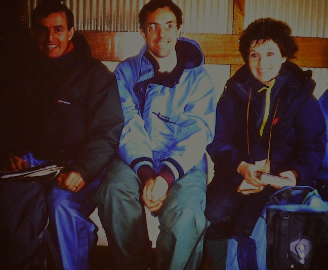
The youth hostel surprised us as it had pews and stained glass. I immediately went to leave the building as I thought we had entered a church by mistake. However, someone came to us without a dog-collar and introduced himself as the warden of the hostel. Then a lycra clad, attractive looking, cyclist called Sue came through the entrance door, at which point I decided it wasn’t a church; the warden explained that it was a former Methodist chapel. Whilst walkers often arrive at hostels in loose clothing, as though they have come straight from the jumble sale, cyclists often arrive in skin-tight lycra with steam rising from taught muscles; it can be most off-putting. Sue had travelled up from London and was cycling around the north of England. She joined us at the pub, where the Black Country Stompers, Clint and Wendy, and another guy from London, Dave, were also obtaining liquid refreshment. There was quite a camaraderie developing amongst us and Coast to Coast was developing into a social whirl, rather than a walk. At times, normally first thing in the morning, you felt it would be better to keep to the socialising rather than the walking. Clint was an interesting character having been a climber and skier. Like me, he doesn’t sleep very well on long-distance walks, his doctor advising him to take sleeping tablets. Given that he also drank and smoked quite heavily, a ‘hangover’ from his climbing days, it was a miracle he was fit enough to do the walk. His claim to fame and fitness was that he had climbed ‘The Old Man of Hoy’, although he didn’t say whether it was twenty or twenty-five years earlier.
When I got back to the hostel I had a look in the drying room to see how the washing I had done earlier was drying. Oops, I had put it high on some drying racks and it had dripped all over the Black Country Stompers clothes that were drying; I was the most unpopular person in the hostel.
Post 31: We eventually found our bed and breakfast and, suffice to say, it was the worst I had ever stayed in. The evening meal consisted of a dollop of mashed potato, one sausage and half a dozen peas. Does this lady not know we had walked 62½ miles to get here? The only thing she seemed keen to provide was newspaper to help dry out our soaking boots; would this be extra on the bill? The house was well ventilated as the windows had huge gaps round them. I would have thought that double-glazing salesmen would have a field day here, but perhaps they haven’t found Shap yet; they have found everywhere else in the British Isles. I am thinking of taking out a court injunction at home to stop me being harassed by double-glazing salesmen.
‘No, no, I don’t want to have my windows replaced yet’
‘When would you like them fitted sir?’
‘Not until the windows drop out. Go to Shap instead.’
It was the bed and breakfast from hell, when you least wanted it. I decided the only escape was the pub, but Archie, suffering from malnutrition, was too tired to even walk the few hundred yards. I also felt exhausted, but remembered I had a wife and two children and needed to make a call home (no mobile phones or email then!) from the local red coin-box phone, to re-assure them they still had a husband and father.
On the way back from the telephone, I noticed the Black Country Stompers in a pub and, not being anti-social, decided to join them. It turned out that they had back-up transport carrying their main luggage for them, no wonder they looked so well, whilst I felt tired out. This was a serious matter, which I referred to the Long-distance Walkers’ ‘Ethics ’ Committee. The decision was that although this was permitted it was not to be encouraged as it detracts from the sense of independence that one gets from carrying a thirty-pound pack. What is this committee? I am the Chairman and Gary is the Secretary. It was formed in a pub when we had nothing else to do for three hours. Its aims are:
1) To encourage interest in and enjoyment of long-distance walking, both for individuals and groups, according to ability and experience.
2) To determine definitive rulings on moral and practical issues concerned with long-distance walking and maintain the highest standards of behaviour of participants (e.g. allowable route, permitted use of transport off the route).
3) To provide a source of information to members and others on new developments, new routes, equipment, literature and courses available.
To encourage you in the history of Shap try and visit the Abbey ruins which were established in 1199, before falling into the destructive hands of Henry VIII in 1540 and fell into disrepair and ruin. He has a lot to answer for! There are famous Shap stones hereabouts, erratic huge granite boulders.
3 April 1991: Day 6 – Shap to Kirkby Stephen Youth Hostel – 22 miles
I woke up thinking I was at the end of the earth. I had a headache and the number 22 was spinning round in my head. Surely, we didn’t have to walk 22 miles today? We walked 19 yesterday; Wainwright was going down in the popularity stakes. Having totally criticised the bed and breakfast, I have to say the breakfast was excellent, a real ‘heart attack breakfast’; after it I felt like a ‘New Man’. On a long-distance walk, fruit-juice, bacon, eggs, sausages, tomatoes, mushrooms, black pudding, fried bread, cereals, toast, coffee is just what the doctor ordered and keeps you going until about 10.30am. If not doing a long-distance walk it is sufficient to give you a heart attack.
It was an early start as we left Shap at 8.45am, with dramatic skies over the Lakeland Fells, sadly left behind We soon reached the M6, a tarmac snake of six lanes. As we looked down on the roaring traffic, this was strangely one of the most uplifting experiences of the walk. I realised how good it was to be away from so called ‘civilisation’. The cars were going seventy to eighty miles per hour, caught up in the ‘rat race’. We were walking at the grand speed of three miles per hour, four downhill and two uphill, free as birds. Yes, it was good to be doing Coast to Coast, and good to be away from the trappings of the modern world; the hardships of Shap were not so bad after all.
POST 30: 2 April 1991: Day 5 – Patterdale Youth Hostel to Shap – 19 miles (normal route is 16 miles)
Relief! My infected blister was a little better. As I walked through reception at 8.00am, I bumped into Theresa who said,
‘You don’t look very happy.’
‘Oh, I’m not awake yet.’
Not a man for swearing, I didn’t like to say her stupid and incorrect advice about the weather had meant me walking extra miles, resulting in sore feet. ‘Are you going to Shap today?’ I enquired.
‘No, we’re stopping half-way.’
‘Oh, perhaps we’ll see you later on during the walk.’ I said hoping that I wouldn’t or, if I did, a suitable revenge could be plotted such as turning a signpost around so that she headed off into a wilderness, never to be seen again. This is probably the reason that, from time to time, signs get turned round – a sure way of getting rid of walkers you don’t get on with. As it happened, I didn’t see her on the walk again.
We left Patterdale at 9.15am in torrential rain. It would have been tempting to stay in Patterdale, which Wainwright points out in his guide, is one of the options. Passing through fields, streams had become gushing rivers and Ullswater was probably twice its normal size. It was at this point that we decided to follow the low-level, longer route along Ullswater, rather than the recommended route over Kidsty Pike. Despite the rain, we made good progress, then, near Howtown, stopped in the doorway of a barn to have a hot drink. It was at this point we encountered the Black Country Stompers, a long distance walking group from the Midlands. They surrounded us, pulled out their lunch packs then, as we were grossly outnumbered, we decided we would have to relinquish our bit of shelter and move on. Such are the hierarchies of the trail. However, right was on our side, so that the rain eased off considerably. We continued over Askham Fell to Butterwick, where, feeling somewhat tired we stopped on a bench, near the road, for lunch.
How about this for an alfresco lunch spotPost lunch relaxation
‘What would you do if a bus to Shap passed by now?’ I asked.
Archie thought hard and long, ‘Oh, we couldn’t get on a bus ’
‘No but what if two blondes in a sports car stopped and offered us a lift to Shap? Now that would be a different matter.’
Clearly five days on the trail were starting to have an effect and we were experiencing delusions and day dreams. Could we last the solitude and mental torture for another nine days?
Fortunately, we soon arrived at Bampton Grange, where there was an inn and an opportunity to bring us back to the real world. Soon after the Black Country Stompers arrived, then Clint and Wendy. There were enough of us to have a party but no one had the energy. With a roaring fire we were able to dry our clothes and the pub looked liked Sketchleys on a busy day. The warmth of the log fire was cosy and comforting, plus there was Guinness to replenish lost nutrients. I could easily have stayed there instead of heading out into the elements. It was not to be; the call of Shap was beckoning and what would I say to all my sponsors who had offered to donate money to the wildlife rescue centre in Scotland if I failed to finish the walk? There is something about walking to Shap that leads one to a negative frame of mind. I think it goes back to my childhood when Shap was always the first place in the country to be cut off by snow and in a child’s eye it was the last place on earth. Here I was walking towards it, conjuring up all sorts of images of bleakness and barrenness. On arrival, in torrential rain and mist, I was not disappointed as we trudged down the windswept main street; we could have been at the North Pole. However, we did find one shop open and managed to re-stock with barley sugars, Yorkie bars and fruit pastilles; my sugar levels were at an all time low.
Post 29. Just a quick note of thanks and to wish all followers of my ‘The Secret Diaries of a Long-distance Walker’ a Merry Christmas and Happy New Year. Since August there have been well over 500 views across 25 countries and so I am very grateful for that and the very kind and complimentary messages I have received. So until the New Year I am going rest my blistered feet, have a drink or two, and contemplate future diary entries on my walks.
These will include, Magician’s Parties, Tattoo Parties, A Youth Hostel with Pews, The Nuts Barn, A Fella aged 169, Hearse Toll Charges of 6D, A Black Eye, The Dad’s Boxing Day Football Match which nearly ended Coast to Coast, Taking Baths Alfresco, Devising my Own Coast to Coast and getting it published, Insect Bites, Adders and the formation of the Walkers Ethic’s Committee.
If you have missed any of the Diaries and want to catch up, this holiday period is a good time to do so (I am sure you will have nothing better to do!).
Have a great 2016 and hope your life is as varied and exciting as mine is on walks!
Post 28: 1 April 1991 (April Fools Day): Day 4 – Grasmere Youth Hostel (Tarn How) to Patterdale Youth Hostel – 9 miles
Wainwright describes this walk as straightforward on a well defined path rising to a high pass and then descending a long valley.
However, the weather forecast was appalling, 70 mph gales, sleet, snow, rain and mist. Who were the April fools? Due to heavy rain, we delayed leaving Grasmere by going in all the outdoor shops, pretending to look at foul weather gear and review every blister kit known to man. Grasmere has a lot of outdoor shops and as the rain pelted down outside we were able to keep warm and dry for a good hour.
However, all good things must come to an end, we couldn’t put the day off any longer. Why is the rain in the Lake District different to anywhere else in England? Did Wordsworth, who lived in Grasmere, ever write any poems describing the rain? Rivers, mountains, valleys, and lakes he could eloquently portray, but I’m not sure about rain. As we climbed Tongue Gill, it was as though someone was throwing buckets of water at us from every angle. In addition, we were in a wind tunnel that could have been used to test Concorde. Arriving at Grisedale Tarn, there were waves on it.
I shouted to Archie, ‘It’s the North Sea,’ only to realise that such a statement was some 138 miles premature. I then made the quickest decision of my life as to whether to follow Wainwright’s high-level route over Helvellyn and Striding Edge. In one second I was striding not up Striding Edge, but down Grisedale Valley. I was to return to Striding Edge in 1995 on another long-distance walk, the week after someone had died there.
Striding Edge on a better day
As we descended we met a mother and teenage son pushing mountain bikes, taking the joys of motherhood to its extremes.
‘It’s rough up there,’ I said trying to be helpful.
‘We know, people keep telling us,’ she replied, continuing to awkwardly push the bikes up and over the rocky, slippery path. The descent would have been interesting to watch.
Arriving at the dilapidated Ruthwaite Lodge, we huddled behind a broken wall for some shelter from the horizontal sleet. As we ate our sodden lunch, a young lad joined us dressed in one those cheap nylon waterproofs that do anything but keep you dry. If the water doesn’t get in from the outside, your sweat will soak you as it cannot escape. Neither did he have a hat, so that his hairstyle could only be described as ‘dripping’.
‘Going to Grasmere?’ I said trying to open a conversation.
‘No, I’m going over Striding Edge,’ he said confidently.
‘Did you know there is snow, ice and severe winds up there?’
‘No, I’ll see what it’s like a bit further on.’
Archie transformed himself into a raging bull and shouted, ‘Don’t be stupid you’ll kill yourself on Striding Edge.’
‘Yes, perhaps your right. I think I’ll give it a miss today.’
At which point, feeling we had done our mountain rescue bit for the day, we marched on down the valley to, ‘Singing in the rain’. What else could we do?
We arrived at the pub in Patterdale at 2.15pm, incorrectly assuming that the hostel would not open until 5.00pm; that was our excuse. Now Patterdale in those days was nothing like the scenes of debauchery and indulgence as portrayed in the TV series ‘The Lakes’. However, it was not for wanting of trying and, whilst drinking over five and a half pints of Guinness to give us energy, we were accosted by a group of Country Holiday Association walkers who, on entering the pub, immediately started stripping. Was this to be the equivalent of a Lake District ‘Full Monty’? We thought our luck was in until we realised everyone who entered the pub did the same, presumably because they were soaking wet from the rain outside. As we enjoyed the communal gathering of walkers, Coast to Coast was taking on a whole new raison d’être. It was here that we made an acquaintance with Clint and his sister, Wendy, both from Guernsey and doing coast to coast, and later to become my walking companions. Fortunately, the hostel was only a short stagger away and, arriving at 5.15pm without getting lost, I slept until dinner at 7.00pm, then slept again until 10.00pm, had a shower, then retired to bed again. Nothing to do with the copious amounts of Guinness drank of course. At 2.15am, I woke up with my big toe really sore realising it had either become infected or had Guinness poisoning. Assuming the former, by torchlight I pierced the blister eight times to ease the pressure. I then applied lashings of anti-septic cream, praying that the treatment would work. Otherwise Coast to Coast was at an end.
Post 27: 31 March 1991: Day 3 – Longthwaite Youth Hostel (Borrowdale) to Grasmere Youth Hostel (Tarn How) – 10 miles
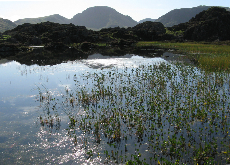
It was with great relief that I awoke in the morning knowing that we only had 10 miles to walk today rather than the 17¾ miles to Patterdale that Wainwright recommends. After the previous two days exertions my legs and feet were aching, but we were able to have a slow start leaving the hostel at 10.30am; well it was a Sunday. Wainwright describes Borrowdale as the fairest of the Lake District valleys and I have to agree; unfortunately on this day it was covered in mist. However, with my new determination to master the skills of navigation we made good progress ascending alongside Stonethwaite Beck, up Greenup Gill, past Eagle Crag, then to the summit of the pass, Greenup Edge.
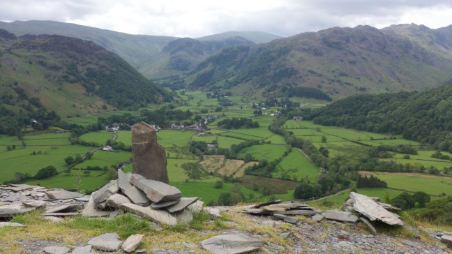
Borrowdale, described by Wainwright as the Golden Mile, viewed from Castle Crag on a better day. Our route passed Eagle Crag, which can be seen in the distance slightly left of middle and then headed over the ridge in the far distance.
To find our way down to Far Easedale in the thick mist I had to use my compass and, to my surprise, we actually followed the correct route. As if to pat us on the back, the mist cleared, the sun came out and, on entering Grasmere, flowers bloomed. We sat outside the hostel waiting for it to open, bathing our battered feet in the sun.
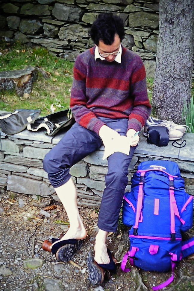
Archie writing his last will and testament and cooling off his feet as we wait for Longthwaite Youth Hostel to open.
Writing a postcard home I said, ‘This is a great experience, if I survive it!’
Top walker’s tip – report in regularly to your wife and family and play the sympathy card by letting them know how much you are suffering.
Post 26: Just then, a couple, having also followed Bill’s instructions, arrived. The young man was ‘miles away’, listening cheerfully to his walkman and oblivious to the fact he was lost. His girlfriend looked totally exhausted and fed up. I looked carefully at my Wainwright guide and realised that Will had missed a crucial segment of text out when quoting from the guide. He should have read: ‘Go past thehut but instead of turning down to the river contour the slope for half a mile to Loft Beck.’ It was so clear now. We had crossed the wrong river/beck and headed completely in the wrong direction. Bill had realised his mistake and had tried to whistle us to get our attention.
One of the walkers from the group already at the Black Sail Pass said he had walked from Borrowdale, would be going back the same way and we could join him. By skirting Kirk Fell we would be able to pick up the Moses Trod path, below Great Gable. I had visions of Moses’ being there, opening up his arms and making a corridor through the mist for us to follow; our deliverance from this misty confusion. The reality was somewhat different and involved some quite rough walking, including crossing the River Liza. Fortunately, I had some barley sugars (in later walks, dried apricots replaced them) to restore energy to aching limbs and gave them out to the small band of despairing and tired walkers. We looked up in the direction of Great Gable, hidden in the mist; it was ironic that, on the previous day, I had joked to Archie that we could always do a quick run up Great Gable. It now seemed a pretty poor joke. However, one of the characteristics of Archie is that he merges into his surroundings; with his head bowed and deathly silence he seemed to become part of the mist. I suspect, under his breath, he was saying what a stupid idiot I was for leading him up here to some 2,000 feet.
Moses Trod was originally a commercial route used by a quarryman, Moses Rigg, to transport his loads of slate by pony from Honister to Wasdale or Ravenglass. He also distilled his own brand of whisky from the bog water on Fleetwith and smuggled the whisky amongst the slate. I could have done with a stiff whisky there and then.
The young man with the walkman was more interested in the football results than his girlfriend’s exhausted state. I suspected their relationship would end either on the walk or soon after it. I think it is probably best not to take your girlfriend or for that matter wife on such long walks, which do ‘test’ friendships and relationships and could lead to arguments when tired.
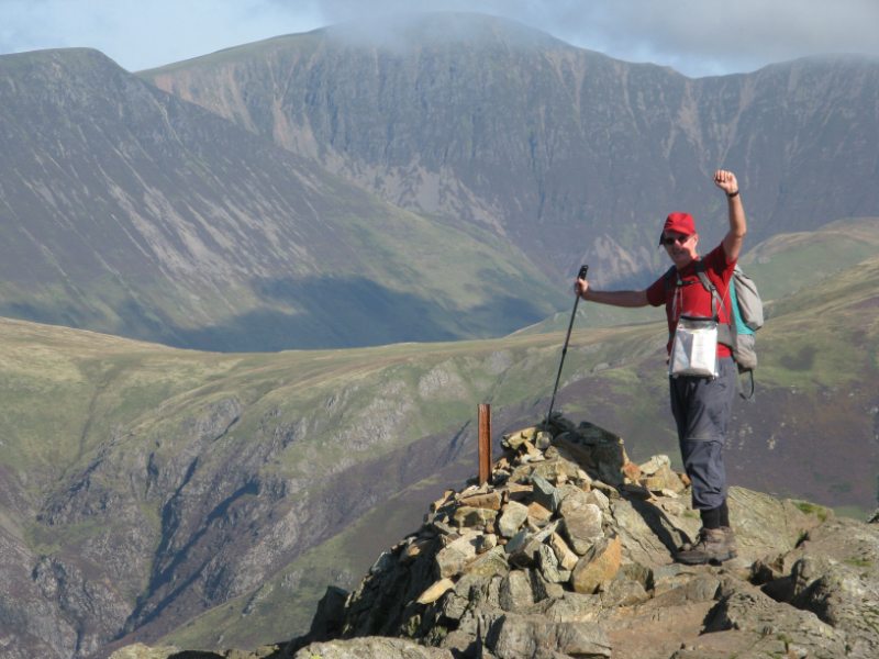
Better to take your daughter than your girlfriend on a long walk as there is less chance of arguments. My daughter, Sophie, on a better day in Ennerdale, taken from the Moses’ Trod path. The route of my Coast to Coast walk in the background, during which nothing could be seen. The Black Sail Hut is in the far distance amongst the trees and the Black Sail Pass is the dip on the far right as looking towards my daughter. The high level route we should have followed is on the left of my daughter.
Our ‘guide’ seemed more uncertain of the route than me but, after a never ending slog, some compass readings and disappointing football results, we arrived at the bottom of Grey Knotts, back on the Coast to Coast route. Then Bill appeared out of the mist on the correct route. We held our breath declining to say anything about their mistake. The foundations of Drum House of Honister Quarry were passed and then the ‘old tramway’ path led down to Honister Youth Hostel. At this point the young lad took off his walkman to at last speak to his girlfriend.
‘We could put up the tent and camp at the youth hostel for the night.’
I butted in. ‘Why don’t you stop in the hostel? You don’t want to have to put a tent up now. Your girlfriend looks exhausted. It’s quite cheap to stay in the hostel and you can get a warm meal and have a comfortable bed.’ For being so cruel he was verbally ‘savaged’ by Archie, his girlfriend and myself. We eventually persuaded him to check whether the hostel had any vacancies, but he clearly didn’t want to spend any money. His luck was in as there were no vacancies.
Archie and myself telephoned Longthwaite Youth Hostel, the next hostel, where we already had a booking and advised them we would be arriving late. Without more ado we carried on to the hostel, leaving the couple to sort out their relationship and a bed for the night.
After a muscle aching descent along the B5289 (we decided not to take the off-road path for fear of getting lost again), we arrived at the youth hostel at 6.30pm. A long day.
Theresa arrived at 7.00pm, but, in case I couldn’t control my temper, I avoided her like the plague. Talking to other walkers in the hostel we quickly discovered that other coast to coasters had ended up lost in the mist all over the Lake District, including in the next valley near Buttermere.
I vowed that day, never to listen to the advice of other walkers and instead improve my own map reading skills.
‘Today’s walk was a piece of cake?’ I joked, as Archie patched up innumerable blisters. He gave me a filthy look. My own feet were throbbing and I had two ‘hard-skin’ blisters on my toes, one of which I had to pierce in the middle of the night with my sewing needle, so easing the ‘pressure’.
Views from the alternative high level route over Haystacks, which would have been fabulous to follow in good weather. Here are photographs taken on better days.
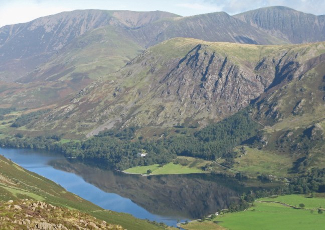
Buttermere from near HaystacksInnominate Tarn where Wainwright’s ashes are scattered. Great Gable in the background.On the summit of Haystacks.Near Haystacks and the outflow of Blackbeck Tarn with Buttermere and Crummock Water in the background.Warnscale Bottom.